hydrographic note for gnss observations against corresponding british admiralty chart positions (to accompany form h.102) h.102b
HYDROGRAPHIC NOTE FOR
GNSS OBSERVATIONS AGAINST CORRESPONDING BRITISH ADMIRALTY CHART
POSITIONS
(To accompany Form H.102)
H.102B
(V7.0 Jan 2014)
Time/Date of Observation
Chart/ENC in use
(SEE NOTE 3a)
Latitude/Longitude of position read from Chart/ECDIS
(SEE NOTE 3b)
Latitude/Longitude of position read from GNSS Receiver (on WGS84)
(SEE NOTE 3c)
Additional Information/Remarks
(SEE NOTE 3d)
Number / ENC
Edition Date & NM / ENC update status
NOTES:
1.
This form is designed to assist in the reporting of observed
differences between WGS84 datum and the geodetic datum of British
Admiralty Charts by mariners, including yachtsmen and should be
submitted as an accompaniment to Form H.102 (full instructions for
the rendering of data are on Form H.102). Where there is
insufficient space on the form an additional sheet should be used.
2.
Objective of GNSS Data Collection
The UK Hydrographic Office would appreciate the reporting of Global
Navigation Satellite Systems (GNSS) positions, referenced to WGS84
datum, at identifiable locations or features on British Admiralty
Charts. Such observations could be used to calculate positional shifts
between WGS84 datum and the geodetic datum for those British Admiralty
Charts which it has not yet been possible to compute the appropriate
shifts. These would be incorporated in future new editions or new
charts and promulgated by Preliminary Notices to Mariners in the
interim.
It is unrealistic to expect that a series of reported WGS84 positions
relating to a given chart will enable it to be referenced to that
datum with the accuracy required for geodetic purposes. Nevertheless,
this provides adequate accuracy for general navigation, considering
the practical limits to the precision of 0.2mm (probably the best
possible under ideal conditions – vessel alongside, good light, sharp
dividers etc), this represents 10 metres on the ground at a chart
scale of 1:50.000.
It is clear that users prefer to have some indication of the magnitude
and direction of the positional shift, together with an assessment of
its likely accuracy, rather than be informed that a definitive answer
cannot be formulated. Consequently, where a WGS84 version has not yet
been produced, many charts now carry approximate shifts relating WGS84
datum to the geodetic datum of the chart. Further observations may
enable these values to be refined with greater confidence.
3.
Details required
a. It is essential that the chart number, edition date and its
correctional state (latest NM) are stated. For ENCs, please state the
ENC name and latest update applied.
b. Position (to 2 decimal places of a minute) of observation point,
using chart graticule or, if ungraduated, relative position by
bearing/distance from prominent charted features (navigation lights,
trig. points, church spires etc.).
c. Position (to 2 decimal places of a minute) of observation point,
using GNSS Receiver. Confirm that GNSS positions are referenced to
WGS84 datum.
d. Include GNSS receiver model and aerial type (if known). Also of
interest: values of PDOP, HDOP or GDOP displayed (indications of
theoretical quality of position fixing depending upon the distribution
of satellites overhead) and any other comments.
 295407-electricity-sensing-waves-and-quantum-physics-mcq-topic-quiz-lesson-element
 OFFICIAL PRIVACY NOTICE – CONTACTING POLICE SCOTLAND DATE OF
 INLEIDING BIJ UW TEVREDENHEIDONDERZOEK U BENT
 DOKTORASANATTA YETERLİK TEZ SAVUNMA VE SÖZLÜ SINAV TUTANAĞI TC
 UNEPCBDSBSTTA99ADD3 PÁGINA 0 CBD CONVENIO SOBRE LA DIVERSIDAD BIOLÓGICA
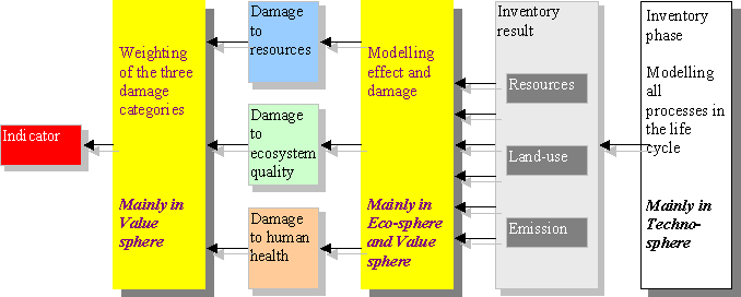 WEEK 6 ECOINDICATORS 99 THE LCA FLOW DIAGRAM OF
 ENGLAND HEALTH AND PERSONAL SOCIAL SERVICES FOR PEOPLE WITHLiberia%20Girls%20Vulnerability%20Assessment